Some men seem destined to a life of action and exploration and Albert Markham definitely falls into this category – but in addition, he was always keen to contribute to advances in science and had a life-long interest in the natural world. These interests were combined in his next adventure.
He did not return to Australia after the Enquiry (see Albert Markham part 2). His enthusiasms deviated towards the renewal of interest in the Arctic. Exploration in the Arctic had ceased after the loss of Sir John Franklin’s ill- fated northern (sailing) expedition of 1845. Sir John, his ships Erebus and Terror, their entire crews, who had set out to find a route through the Northwest Passage, had disappeared without trace. A number of expensive searches to find clues as to the cause of the disaster had been unsuccessful and because of this, government enthusiasm for northern adventure had diminished. But, by the 1870’s the Royal Geographical Society had begun to push for a renewed thrust north. Albert’s cousin, Clements Markham was one of the Society’s officials who called for government support for Arctic exploration. There was a concern that the prolonged peace that the country had experienced had ‘softened’ its naval officers in a detrimental way. The Society’s officials opined that exploration would provide a much needed stimulus.
The government needed to be convinced. Although today, the Arctic is a source of international interest and conflicting ambitions, official support for a reduction in global warming is likely to be balanced by the desire to take advantage of both reduced shipping times as the ice melts and the possibilities of oil and mineral extraction – this was not the case in the 1870s. Information about Arctic conditions was sparse. It was uncertain what, or indeed if any, benefits would result from further knowledge. A recce by an intelligent naval officer was required. Markham volunteered and was appointed in 1873. Remarkably he relinquished his previous naval status (Commander) and sailed as a Second Mate crew member on a whaling steamer going to Baffin Bay. His aim, apart from studying whaling, was: to report on how steamers could manage the icy conditions of the Davis Strait and the Baffin Sea (see map), to assess the best route for steam vessels and to consider the best location from which to make an attempt on the North Pole.
When he was on this whaling excursion Markham had the opportunity to question survivors of an ill-fated American ship, the USS Polaris, which had been caught in the ice on her return from her northern voyage and eventually crushed. These men advised Markham about the conditions in Smith Sound, the passage between Greenland and Ellesmere Island (see map), which links Baffin Bay with the Lincoln Sea. They considered that Smith Sound would be the best place from which to approach the North Pole – they told Markham that they had experienced a ‘mild’ temperature in the area and there had been little snow. This was encouraging news for Markham. When he returned to England he published, A Whaling Cruise to Baffin’s Bay and the Gulf of Boothia, and an Account of the Rescue of the Crew of the Polaris. He gave lectures. He concluded that Ellesmere Island would be the best place for a base from which to attempt to reach the North Pole. However clearly, no one, at that time, fully appreciated the dramatic change in conditions that can occur between seasons.

Map of Sir George Nares’ progress north
Support for the northern expedition was given by the Royal Geographical Society and by Prime Minister, Disraeli. Her Majesty’s Government accepted and financed the proposal which would ‘advance scientific knowledge and encourage the spirit of maritime enterprise’.
The British Arctic Expedition (1875-76), was led by Sir George Nares. There were two ships, the Alert, captained by Sir George and the Discovery. captained by Henry Stephenson. Markham was second-in-command on Alert. Sir George’s brief was to advance along the west coast of Greenland via Smith Sound(see map). From here, it was believed, there would be open water as far as the pole over which the expedition would sail. In essence Nares was to get as far as possible to the North Pole and to explore whatever coasts the travelling parties could reach.
After a departure in May 1875, progress was slow. The Arctic Circle was crossed on the 4th July followed by slow progress up the west coast of Greenland towards Smith Sound. The entry to Smith Sound was obstructed by thick masses of ice. Nares, had to wait patiently for lanes to open before progressing, often at less than a mile per day. The conditions were far, far worse than expected from the descriptions Markham had been given by the Americans but Nares was the first to take his ships all the way north to the Lincoln Sea. The assumption that this would then open to an ice-free region that surrounded the pole was completely false – Nares found that the reality was a wasteland of ice – the polar sea was a myth.The ships progressed north with caution, sometimes waiting for lanes to open up, sometimes boring through ice floes, until they reached Lady Franklin Bay at 81°4’N. Here there was a good supply of fresh meat (musk).Fresh meat was thought to be helpful in the fight against scurvy because of its vitamin C content (in fact it contains virtually none) and here Nares decided that Discovery should set up winter quarters. Discovery would act as a secondary base should some disaster befall Alert.
Alert continued her northward progress around the tip of Grant Land (the northern part of Ellesmere Island) and in early September 1875 Nares reached 82°24’N. Fifteen days later he reached 82°27’N, and made his base in a bay safe enough to winter in.

Map of Islands around North Pole showing Lincoln Sea between Lincoln Sea and Ellesmere Island

Alert in the Arctic ice
From this base teams were sent out to explore the region and collect as much scientific data as possible. Markham led one of these sorties. The men were totally unprepared for the dreadful conditions, their sealskin suits and wool guernseys did not give adequate protection, they got soaked and then iced up. Markham turned back after only four days. A second sortie was attempted. This time the team had to battle with big ice ridges – they had to unload all the items from the sledge, carry them over the ridges and then repack the sledges Markham decided to halt the advance in early October. He left the site as the expeditions newest northernmost depot. No more expeditions were attempted before the winter.
The achievements of the 1875 expedition were: the British flag had been taken further north than had previously been reached, and unknown regions had been explored and charted.
Both Nares and Markham were concerned for, and considerate of, the welfare of their men. The winter months passed surprisingly smoothly considering the conditions. Entertainment was provided: an ice rink, firework displays, boxing matches, and most importantly, evening classes. ‘The Royal Arctic Theatre’ featured the officers’ attempts to entertain the crew.
The sun appeared after 142 days and the early part of 1876 was spent continuing to collet data and specimens and in charting Ellesmere Island.
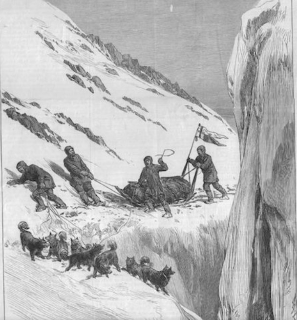
In April, Albert Markham and Lieutenant Alfred Parr led a Pole Party of fifteen men, pulling two sledges, boats and three support sledges. Leaving their base at 82°27’N the Markham party initially travelled with another group led by a Lieutenant Aldridge, from whom they separated after two weeks. The men battled again through the most atrocious conditions – deep snow and more large hummocks (mounds), through which they had to cut a path with shovels and pick axes Some days they covered seven miles, some days very few and on other days they had to just had to wait for storms to pass. Their clothes froze solid, their sleeping bags became encrusted in ice from breath and sweat and increased in weight. They were exhausted, but what was to finally incapacitate them was the onset of scurvy, the dread of all long expeditions and voyages.
It is now known that scurvy is due to a deficiency of vitamin C. However the concept of vitamins had not been considered in the 1870s, although it was known from the seminal work of James Lind in the 1740s, that a mixture of oranges and lemons resulted in a rapid improvement in symptoms. Unfortunately, in 1870, the Navy was issuing lime juice to its personnel. The juice, sourced in the West Indies, had less antiscorbutic qualities than lemon.[1]
Markham seems to have taken time to realize that the problem was scurvy – he knew that they had eaten meat, which was thought to be helpful against scurvy.[2] He thought his men were simply suffering from swollen knees and ankles due to their exertions (he clearly did not think of examining their gums), but as progress became slower and slower and more men became incapacitated, the diagnosis became obvious. He was to be criticized in the subsequent enquiry for not taking a sufficiency of lime juice on his sortie. Eventually the sick men had to be hauled on sledges by their already weakened companions.

Further Manhauling
With what seems in retrospect to be unbelievable determination, Markham continued north until he reached 83° 20’N. in May (see map of Progress North and map below). This region was 400 miles from the Pole, the furthest north that had been achieved.
By this time only a few men were still able to function adequately and he had to turn back. Even then his courage did not desert him and he arranged a flag raising ceremony (and some more observations)

Painted by Richard Brydges Beachey
The return journey was yet another a battle to survive, the pack ice was melting, it was important to get to firm land before being cut off on ice floes (and having to man those boats). The team deteriorated to an extent that, forty miles from base, there were only two officers and two men fit enough to work, a potentially disastrous situation. Here Lieutenant Alfred Parr, Markham’s second in command, showed his sterling qualities. He volunteered to make a solo sortie to get help. This risky, brave journey – he did not stop for twenty four hours – brought rescue teams to Markham’s desolate group. There was one death. It is said that when they reached Alert, of the over fifty men on board, only three men could actually walk.
Nares decided to return to England a year earlier than planned. His two ships reached Portsmouth in November 1876. He could claim that the expedition had explored an area that was previously unknown, they had reached a record northern latitude, had mapped a considerable portion of the north Greenland coast and collected much significant scientific data.
The reception in England was mixed. Predictably questions and criticism soon surfaced. Although Queen Victoria applauded the expedition’s achievements and Nares was awarded the Royal Geographical Society’s Gold Medal and Markham was given a gold watch by the society, the press and public opinion was critical. It was said that the expedition had failed in its goal of reaching the Pole, there had been much illness due to scurvy, and a death. An official inquiry blamed Nares for failing to carry out orders correctly The expedition was (unbelievably), dubbed ‘The Polar Failure’. Markham was blamed for not taking a sufficiency of lime juice for his crew on his north pole sortie – although, as mentioned above, it is doubtful even if the lime juice had been issued, this would have improved the outcome to any significant extent.
This expedition extinguished the Admiralty’s interest in Arctic exploration and Albert Markham was criticized, particularly over the lime juice deficiency. But his record of determination, his sense of duty and his achievements were obvious. This was officially recognized when he was promoted to Captain.
TO BE CONTINUED
[1] The lime juice from the West Indies contained less vitamin C than lemon juice and was transported across the Atlantic in containers that further damaged its potency. i.e. it was relatively inefficient
[2] Meat contains little vitamin C. Heating causes further damage
